Make tracks to city beaches in Vancouver
If there’s one sight visitors to Vancouver seek on arrival, it’s the Pacific Ocean. For neophytes, that initial encounter often proves underwhelming. They can be excused for asking what time the surf comes up. The rhythm of the world’s largest body of water is decidedly more muted around the city’s shoreline than farther afield on the wave-thumped west coast of Vancouver Island. However, once expectations have been rejigged to match reality, there’s a magical world to discover during an outing along the inland sea.
Here are three easily reached spots to dip a finger in the brine. One salty lick will confirm the truth that here lies a vast marine frontier whose borders define the shorelines of four continents. Come along and sample one for yourself, each of which displays a unique identity of its own.
The strands that ring Point Grey on the city’s West Side offer a variety of approaches, from the easy-to-reach Arcadia Beach on Vancouver’s outer harbour adjacent Spanish Banks to the slippery slopes of Trail 7, which winds downhill from a viewpoint on Southwest Marine Drive. If the tides permit, you could spend a day traversing the five kilometres of shoreline between the two. Of the five main access points, Trail 4, which begins on the north side of the UBC Museum of Anthropology, offers the most variety, both ecological and cultural.
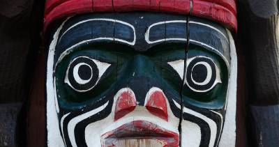
Traditional welcoming figures carved by Musqueam artist Susan Point and ceremonial poles hewn by master Haida artist Bill Reid, among others, define the approach. Behind the larger of two longhouses, a sturdily built trail leads down from the lip of a sandstone cliff almost 400 steps to the beach below. As Trail 4 descends, its staircases pass through Pacific Spirit Regional Park’s lush forest of ferns, alders, and evergreens. Where the path ushers out onto Wreck Beach, massive driftwood logs and root balls lie mired in the sand. Barring a major storm, it’s unlikely the jumble will drift away soon. This suits beach regulars, who shelter behind them just fine. In warm weather, this is one of the more discreet clothing-optional sections of the park, the flip side of the carnival atmosphere found farther west at the foot of Trail 6.
Scan the surroundings from this serene vantage point. To the east, most of the city’s skyline lies hidden from view, while to the west lies horizon on ocean. Islands in the Strait of Georgia lie shrouded in haze; to the north, the Tantalus Range’s wall of peaks at the head of Howe Sound rise white and formidable. Closer at hand, across the mouth of Burrard Inlet, trails on three of Cypress Provincial Park’s peaks herald where skiers and snowboarders play. A rocky breakwater demarcates the beach into sand on one side and cobble-sized gravel on the other.
Unlike city beaches elsewhere, only here do you begin to sense a vastness of oceanic proportions. Depending on the level of the tide, either scramble west below the weathered cliff’s smooth face or pick your way east toward two concrete Second World War artillery towers emblazoned with a crazy patchwork of spray-painted images, such as a tawny mutant whose face gleams out at the foot of Trail 3. Find a log to perch on and let the lapping of the waves go to work on your mind. For detailed information, contact Metro Vancouver Park’s West Area office, 604-224-5739, or visit www.metrovancouver.org/ and do a search for Pacific Spirit Park.
Of all the waterfront approaches in Stanley Park, Third Beach offers the most serenity. Perhaps it’s the calming influence of poet Pauline Johnson, credited with naming Lost Lagoon, whose memorial sits tucked away in a shaded grotto above the beach. From this crescent-shaped strand tucked midway between Second Beach and Siwash Rock, look west toward the snowcapped Vancouver Island mountain ranges. Like blinders, the forested slopes of the peninsula surrounding the beach shield most else from view, including English Bay and the North Shore. Even though passersby on the seawall overlook the beach, seclusion can be found by tucking into one of the upturned corners of the beach’s smile.
The copper-hued colour of the sand is unique to Third Beach, the product of relentless wave action on a sandstone reef offshore. Crimson of a different tone is displayed above the beach, where one of the largest red alders in Canada anchors the grassy hillside just west of a concession stand. To further enhance a visit, follow the pathway that leads uphill through a formidable grove of western red cedar, western hemlock, and broadleaf maple. Rainforest and oceanfront combine here in a classic West Coast environment. For a detailed map of Stanley Park, visit www.vancouver.ca/parks/parks/stanley/.
Finally, Portside at Crab Park offers one of the best views of the working harbour from one of Vancouver’s tiniest beaches. This site was once called Luckylucky, or Grove of Beautiful Trees, by local First Nations paddlers. A sand-and-pebble beach adjoins a viewing pier. Seek out several sculpture installations placed in the pocket park that has been landscaped with grace. Don’t miss the brace of Chinese lions mounted on either side of the overpass that leads into the park from the north foot of Main Street. The duo perfectly frames the Sisters, Vancouver’s iconic twin peaks, more commonly known today as the Lions. There’s more to entertain the eye here than it seems possible to squeeze into one encounter with the Pacific.


Comments