Magnitude 6.2 earthquake strikes on Christmas Eve near Vancouver Island after six B.C. seismic events on Monday
Update: Two aftershocks from this quake occurred on December 25. For more information, see this article.
There's a whole lotta shakin' going off the B.C. coast.
It’s Christmas Eve and significant seismic activity continues to rumble in the offshore region north of Vancouver Island—with the latest temblor registering as the largest magnitude yet.
The seventh notable quake in the Vancouver Island region struck at 7:36 p.m. today (December 24).
Earthquakes Canada reported it as a 6.2-magnitude while the U.S. Geological Survey measured it as 6.3-magnitude.
The epicentre, at a depth of five kilometres (three miles) was located 188 kilometres (117 miles) west of Port Hardy, 334 kilometres (207 miles) northwest of Tofino, 345 kilometres (214 miles) west of Campbell River, and 522 kilometres (323 miles) northwest of Vancouver.

That followed five earthquakes ranging from magnitude 4.8 to 6.0 on the previous day in the same general area.
A sixth earthquake on December 23 occurred near Haida Gwaii, measuring 4.3 magnitude.
There are no reported injuries from the Christmas Eve earthquake in the Pacific Ocean, according to Earthquakes Canada.
No tsunami has been reported from any of the recent seismic events off the B.C. coast.
If a large earthquake hits, people are advised to take cover under a sturdy table or desk and hold onto the table leg until the shaking stops.
If they're not near a table, it's recommended that people remain where they are, cover their face and head with their arms, and crouch down in a corner of the room.
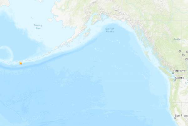 U.S. Geological Survey
 Meanwhile, an earthquake also took place in Alaska’s Aleutian Islands chain about half an hour before today's Vancouver Island region quake.
The U.S. Geological Survey reported that a 4.3-magnitude quake occurred at 7:08 p.m. (B.C. time) offshore from Alaska's Andreanof Islands, which are located approximately midway between the Alaskan mainland and Russia.
The epicentre, at a depth of 54 kilometres (36 miles), was located 43 kilometres (27 miles) south of Adak, Alaska.


Comments