Brian Palmquist: Will Vancouver make the right planning choices to preserve its spectacular natural views?
By Brian Palmquist
When I arrived in Vancouver in the mid-1970s, anything was possible for an architect. Pundits disparaged the city, calling it “a setting in search of a city”. I only saw a profusion of architecture, mountains, and water. This is the first of a series of articles describing how we have reached a crossroads: if we choose the wrong road, we will instead become “a setting lost to the city".
“We lost because of the waterfront walkway,” mused my former mentor, Rein Raimet, one of the partners at Bain Burroughs Hanson Raimet Architects (BBHR), my first Vancouver employer. I had moved to Vancouver too late to work on their second-place entry for the competition to design a community on the south shore of False Creek.
Not bitter but contemplative, he continued. “There was lots of waterfront access in our scheme, but TBP’s scheme had a continuous waterfront walkway. We didn’t realize how key that was.” TBP was local shorthand for Thompson Berwick Pratt & Partners, at the time the largest architectual firm on the west coast and the 1975 winners of the city-sponsored competition.
As the south shore unfolded under TBP’s design stewardship, the young firm of BBHR was not left out, designing several projects. Actually, I think they felt quite privileged: in addition to TBP, architects for the various projects included well-established Vancouver firms like Downs|Archambault, Rhone & Iredale, and Henriquez & Todd, all known for the high quality of their designs. For me, it was a master class in architecture and urban design.
Under the political leadership of then-mayor Art Phillips and The Electors' Action Movement (TEAM), a municipal political party he cofounded, False Creek South also included a mix of tenure never before attempted in Canada: condominiums, housing cooperatives, rental housing, seniors housing, personal care (now called long-term care), and housing for the severely disabled.
There was even a star-shaped liveaboard marina with a shared central building for storage lockers, showers, etcetera. All these forms of tenure coexist to this day, supported by local food stores, restaurants, an elementary school, and cafes set amid park spaces and a continuous waterfront walkway open to all. (A later article in this series will talk about the current uncertainty surrounding this neighbourhood.)
TEAM and the mayor, together with planning staff led by director of planning Ray Spaxman, set at least three key precedents in the planning of False Creek South: the housing mix, the parks, and the waterfront walkway. I don’t believe most Vancouverites realize how valuable these precedents were to the next decades of Vancouver city planning.
Twelve years after my conversation with Rein, I was privileged to serve as managing architect of the Pacific Place Design Consortium for the community-planning phase of the north shore of False Creek (FCN), a.k.a. the Concord Pacific, or Expo, lands. The consortium included 20 to 30 team members with my employer, Richard Hulbert, as lead architect; it also included staff and principals from Downs|Archambault Architects and Davidson Yuen Architects. Later, again with Hulbert, I was also the managing architect for the first two rezoning phases of the Coal Harbour development. I’m not bragging—it just gave me perspective.
Now, “managing architect” is not as glamorous as it might sound—think of herding cats as a suitable simile for keeping multifirm planning and design teams focused. My position managing urban-design processes required me to attend way too many meetings and presentations.

However, these exposed me to the repeated simple clarity of what started in False Creek South (FCS) and continued until recently. For every large-scale waterside development that followed FCS, the city’s staff planners and politicians insisted on these minimum requirements: a continuous waterfront walkway accessible to all pedestrians and cyclists; a significant percentage of lands given over for parks, with all improvements paid for by the developer and handed over to Vancouver's citizens to own, manage, and enjoy; local retail/commercial space; and a mandatory percentage of what was then called “social housing”: housing cooperatives back when senior government still funded them and, later, rental housing with rent controls.
Larger projects such as Coal Harbour and FCN also included school and community-centre sites with construction funding by the developer.
I witnessed regular pushback around these requirements, and not only from the project developers, who are often cast as de facto villains. Two examples immediately spring to mind: Firstly, the school board thought there would be no children living in FCN, so it did not want to operate an elementary school, even with the site provided and the construction paid for by the developer. (Every year now, the Elsie Roy Elementary School in FCN hosts neighbourhood parents who line up overnight to enrol their children.)
Secondly, the detailed design of waterfront walkways, the interface between the city and the ocean, involved a myriad of requirements from the federal Department of Fisheries and Oceans (DFO), which sometimes disagreed with park board staff about what was best for the fishies. (I quietly rooted for DFO and the fishies, who usually won!)

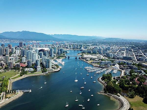
The heights of these megaproject towers that join downtown to Stanley Park and ring False Creek were formed by one other key element of Vancouver’s planning for the past 30 years: the "view cones". These 26 view corridors were enshrined by city council during the transition in 1989 from planning director Spaxman to his successor for downtown planning, Larry Beasley. They applied to FCN and Coal Harbour and just about every subsequent high-rise project…at least until now.
So what is a view cone, anyway? To check one out for real, take a pleasant walk along the FCS seawall, heading east from Granville Island. After a couple hundred metres of walking—past two housing co-ops, a seniors long-term care facility, and two condo projects—you will arrive at a small, somewhat defaced plaque that identifies view cone A from the city’s 2011 View Protection Guidelines map:

Look up and you will see Mount Seymour. This is a fairly narrow view cone—notice how the towers to left and right break the mountain skyline. Before you move on, think about the changes to that view if each of the lower towers beneath Mount Seymour was even a few storeys taller—preserving that view for all citizens and visitors is what view cones do.
To be clear, these view cones are rather arbitrary, arising as they do from Queen Elizabeth Park, City Hall, and Granville Island, but mostly from False Creek South’s parks, open spaces, and shores. They are designed to preserve views of our mountains and waters from the more densely populated neighbourhoods of our city, our “setting in search of a city”. They were pervasive in their extent and inviolable...at least until now.
It’s often challenging to understand the impact view cones have had on the experience of Vancouver. It’s only when you begin to contemplate what we would (not) see in their absence that their essential “Vancouverness” becomes evident.
During my two-year term on Vancouver’s Urban Design Panel, from 1988 to 1990, I reviewed with respected colleagues dozens of Downtown South, downtown core, and False Creek Northeast developments proposed on the coattails of FCN. These were almost all subject to view-cone height limits, resulting in a chess board of heights to duck under what the view cones would allow. Many towers were repositioned on their blocks to avoid the cones, resulting in a richer streetscape at the street level. The city required respect for shadowing of streets and open spaces back then, which also led to many of the relatively thin towers to which we remain neighbours.

Imagine if every already existing tower from Burrard Inlet south to False Creek and from the West End's Denman Street east to Main Street was uniformly 30-plus storeys in height—just walk around any downtown residential neighbourhood, count the existing tower floors, and try to imagine the balance filled in to 100 metres in height.
In fairness, some buildings are somewhat constrained by smaller sites, which might result in lower tower heights in some places. But that might just as well have resulted in the joining together of two or more adjacent sites so that they could share, perhaps, a single 30-plus-storey tower instead of two 12- to 15-storey events—upper storeys always command higher rents or sales prices, so this is not an unreasonable thought. I can’t contemplate every possibility—hopefully, you get the picture of variety versus tall monotony.

None of this may be news to many readers, especially those in the planning and design professions. But this history begins to set the stage for today’s challenges.
The next article in this series will look at the current state of view cones—the pressures they face, what we will lose with their removal, and how the impacts of that loss are largely being hidden from us. Or it could be simply that city planning staff no longer care like they did in the days that spawned the aspirational term coined by former co-director of planning Beasley: Vancouverism.
I keep coming back to Joni Mitchell’s lyrics from "Big Yellow Taxi": "you don’t know what you've got / 'til it’s gone".


Comments