Value of Surrey lot designated by 2020 city plan for townhouses jumps 55 percent to $8.3 million
Here’s an example of how new city plans drive up property values, which could ultimately result in higher home prices.
The assessment of a Surrey lot designated by a 2020 plan for townhouses has jumped 55 percent.
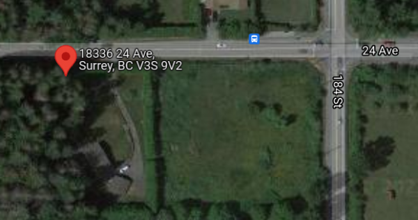
The 2021 valuation of 18336 24 Avenue, which measures 3.73 acres or 1.5 hectares, totals $8,364,000.
This represents a significant increase from the 2020 assessment of $5,407,000.
The rise follows last year’s approval by Surrey city council of a new community plan for Redwood Heights, where the property is located.
As a B.C. property assessment appeal board (PAAB) recalled, the Redwood Heights Area Plan (RHAP) was adopted by council on May 4, 2020.
The 2021 assessment of properties in the province is determined by their value as of July 31, 2020.
The RHAP designates the parcel as a site for townhouse development with a permissible number of 30 units per acre.
Moreover, two percent of the site is “unusable for future development which is specified to be used as a park, natural areas and buffer”.
This results in an area useable for development at 3.655 acres.
A Property Assessment Review Panel pegged the 2021 assessment of 18336 24 Avenue at $8,364,000.
The assessment placed a minimal value of $10,000 for the dwelling, which is a two-storey detached home.
Most of the valuation or 8,354,000 was for the land useable for townhouse development of 3.655 acres.
Adam M. Rosenblatt owns the property, and he believes that the valuation is too high.
As the PAAB related, Rosenblatt thinks that the assessment should be $2,050,000 per acre, for a total value of $7,482,500.
In a decision and order, assessment appeal board chair Edwina Nearhood upheld the property’s assessment at $8,364,000.
Nearhood reached the conclusion after considering three sales of comparable Surrey properties that were presented by Rosenblatt and the assessor.
“The three sales provided by both parties indicate a range in values of $2,300,000 to $2,600,000 per the Appellant and $2,299,000 to $2,520,000 per the Assessor,” Nearhood wrote.
The chair continued, “Based on the evidence before me, a value of $2,300,000 offers a reasonable indication of value for the Subject. Therefore, $2,300,000 x 3.655 useable acres = $8,406,500.”
Nearhood noted that the property’s 2021 assessed value of $8,364,000 actually “falls below this range at $2,236,678 per acre”.
“In reaching this conclusion, I do offer that valuation of real estate is not an exact science,” Nearhood explained.
The chair noted that the Board and courts have “noted that there may be a range of values where all values within the range constitute actual value”.
“The Board has typically found that appraisal tolerances may be 5% or more for a variety of property types,” Nearhood wrote.
The chair added, “Here my finding of $8,406,500 is 0.50% above the assessed value of $8,364,000 confirming the assessed value well within a reasonable range of values.”


Comments